All Activity
- Yesterday
-
 fc_jurgen joined the community
 -

Create Field Dimensions and Farmland Tutorial
WrinkleysRule replied to WrinkleysRule's topic in Mapping
I will have a play around and see if I can replicate this problem. -

Create Field Dimensions and Farmland Tutorial
Brummie Farmer replied to WrinkleysRule's topic in Mapping
yeah, I followed what it said in tutorial and painted entire map after ticking boxes 1-7 -
Create Field Dimensions and Farmland Tutorial
WrinkleysRule replied to WrinkleysRule's topic in Mapping
You did start off with a blank info layer as that can sometimes affect the result. -
Create Field Dimensions and Farmland Tutorial
Brummie Farmer replied to WrinkleysRule's topic in Mapping
That is exactly the same as I have done, I just can't get it to show... Looks like I will have to do it the old way. Thanks for trying to help. -
Create Field Dimensions and Farmland Tutorial
WrinkleysRule replied to WrinkleysRule's topic in Mapping
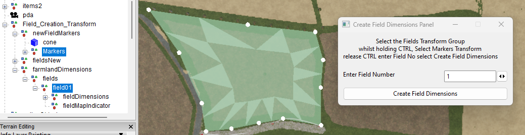
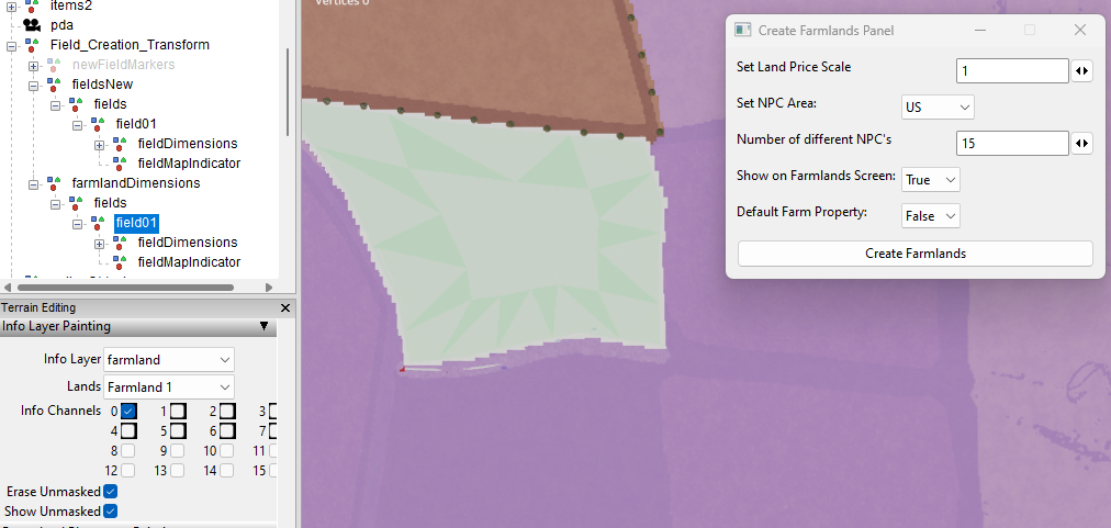
Below are two images which show how I create the farmlands. The first shows the new field dimensions for the farmland area. Note : the farmaland area includes the field boundary as well otherwise you will have to buy a seperate parcel of land as well as the field. The second screenshot shows the farmlands area painted and selected in GE in the Info Layer Painting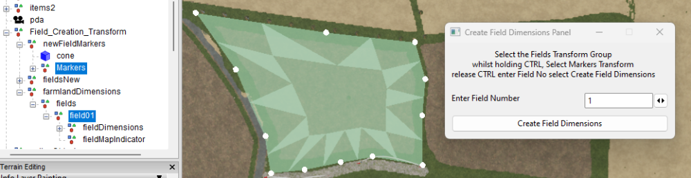

-
Create Field Dimensions and Farmland Tutorial
Brummie Farmer replied to WrinkleysRule's topic in Mapping
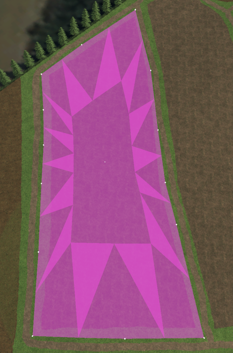
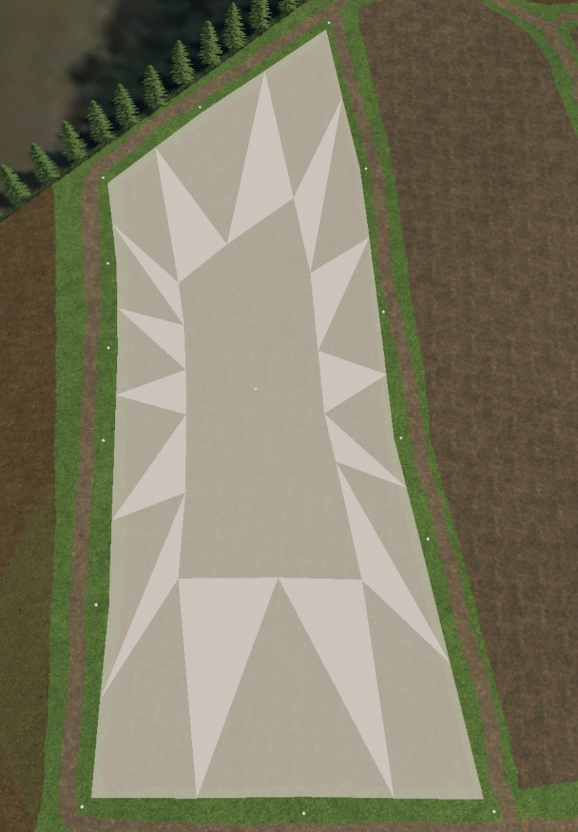
I have tried starting from scratch again, but still not working, not sure why, but i have added screenshots. 1 is the field generated. 1 is the field generation for the farmland and the other is when Info Layer selected. It creates the entry in in xml, but I just can't get it to show in ge tbh I didn't even notice the double foldr, it happened when I unzipped from download, there is folder inside folder, but I corrected that now 🙂


-
Create Field Dimensions and Farmland Tutorial
WrinkleysRule replied to WrinkleysRule's topic in Mapping
I have just downloaded and tried the script several times and I am getting no errors in execution. The error points to a problem in the field dimension creation so I suggest you check/redo the Create Field Dimensions script and see if that helps. For the farmland paint to show up in GE the Terrain Info Layer Paint Mode must be selected and the relevant Info Layer 'farmland' and Lands (field no) must be selected. Nothing to do with the error but bit curious about this double folder entry C:/Users/Brummie Farmer/AppData/Local/GIANTS Editor 64bit 9.0.6/scripts/Field Dimensions and Farmlands/Field Dimensions and Farmlands/Create Farmlands Panel -
 Sib joined the community
 -
Create Field Dimensions and Farmland Tutorial
Brummie Farmer replied to WrinkleysRule's topic in Mapping
Just downloaded script and started using it, created first field no issues, when i tried to create the farmland got this error Error: Running LUA method 'UIButton::onClick'. C:/Users/Brummie Farmer/AppData/Local/GIANTS Editor 64bit 9.0.6/scripts/Field Dimensions and Farmlands/Field Dimensions and Farmlands/Create Farmlands Panel.lua:199: attempt to index local 'modifier' (a nil value) it creates the line in farlands.xml, but it does not paint the farmland onto the map. I followed the above tutorial and tried 5-6 times, but still can't get it to work. -
 Anni joined the community
 - Last week
-
 Hrabia joined the community
 -
 whatsburning1 joined the community
 -
what about a warehouse where i can put crops in like Wheat Barley soybeans Etc. it will store them like a silo but not a silo if that makes sense
-
 bsolesbee joined the community
 -
 Yefim Rasko joined the community
 -
 Countryside Gaming joined the community
 -
 Lorex joined the community
 -
 machok19 joined the community
 - Earlier
-
Open windows explorer select the the three dots at the top In the dropdown select options In the folder options pop up select view Under Hidden files and folders select Show Hidden files,folders and drives Select apply app data folder should now be visible in C:/Users/******
-
i cant seem to access the file this needs to be put into. i can go all the way to C:/Users/****** but then after that cant find the app data folder. only folders listed are as follows ansel apple contacts documents desktop downloads favorites links music one drive pictures saved games searches videos
-
You can look at Morris as an example of a 12km playable area hosted on a 16X map. It is on itchio. Just Google/Bing: FS22 Morris Manitoba Map
-
I am a bit confused as to what you are trying to achieve, if you want a 'farm' area of 12k x 12k then simply create a 16k x 16k map and only use the 12k x 12k section leaving the 4k surplus as a border area then if rquired add a further border mesh to get the overall 20k x 20k area you seem to want (judging by your KMZ files).
-
Hi again thank you so much for that got it done quickly and easily, i learn more complex stuff from you than all of my teachers and you make it so easy. im now stuck on my borders not lining up, i have uploaded a zip to google drive, it includes the tiff, the refrence lines for google maps, a blender file (3.6) and dems for the border with the cover textures. My dem is a 12km terrain squeezed into a think an 8x as my plane doesn’t line up as 16344 or 8192 scale https://drive.google.com/file/d/1xGHILKeVGOTzGvmywCtdBNFsqdctoEYk/view?usp=drivesdk Could you please guide me as to where im going wrong thanks MARVVV
-
To get a proper dem you will need to combine all the 26 tiifs into one single tiff using a programm such as QGIS this will then even out the different shadings and gaps usually found when importing UK lidar directly into Google Earth. The following is one combining method using QGIS QGIS download from here https://qgis.org/en/site/ --approx 1.2gb Once downloaded/installed in the folder QGIS 3.36.0 select QGIS Desktop 3.36.0 select Plugins You now require the following plugins Virtual Raster Builder -- may need to be reinstalled (without uninstalling) to remove error message go2streetview Google Earth Engine Grass GIS provider KML Tools LAStools Raster Cutter Once you have the plugins installed Select Project -- Properties - CRS and ensure the EPSG:27700 - OSGB36/ British National Grid is selected (tip in filter type 27700 to bring up the correct entry to select) this setting is important for alignment between the different CRS of Google and OSGB which causes the splits between rasters when imported directly into Google Earth. Next Settings -- Rendering -- Raster -- Contrast Enhancement -- Single Band Grey --Stretch to min/Max --selected in dropdown Drag and drop all the Defra tif images into the the main screen they will open in seperate Layers Now select Raster -- Miscellaneous --Build Virtual Raster At the end of the Input Layers box select the 3 dots this will bring up another pop up with a list of all the layers in your Layers panel Select All then Run A new Layer will appear named Virtual with all the selected Layers merged into one image with the correct brightness/contrast To save this virtual file as a tif right click on it Export -- Save As in the 'Save Raster Layer as' pop up Select Rendered Image Select the three dots at the end of the filename box to open a file browser add file name Save and in Save Raster layer pop up select OK Open Google Earth and drag drop new file into it NOTE: The CRS EPSG:27700 - OSGB36/British National Grid setting only applies to UK Lidar for any other SRTM Tiff the setting has to be changed to match that tiffs CRS.
-
 Thank you for sharing your knowledge and experience in Modding BD I've learned so much from being a subscriber to your You Tube Channel The xml script for Discharge options much appreciated! The only problem I have is Trac Color changing. Thanks BDbssb oh yea Congrats on getting your new Mod into GIANTS Mod Hub!
 -
Hey guys, im redoing my dem trying to use the British LiDAR information, as it’s a 16x map I’m kinda brain hurt as not only have I got 26 different tiffs, I have below sea level areas down to like -10 and areas upwards of 315m (google earth) on some of the outside borders, I’ve been trying my best going over and over to no brake through, obviously I was hoping I could just import the tifs into google earth (which I have). and just copy that layout into a dem but for obvious reasons it’s too hilly (Mendip hills to Somerset levels) if you could point me in the right direction I would be grateful as going in circles for 20 hours isn’t the best thanks MARVVV
-
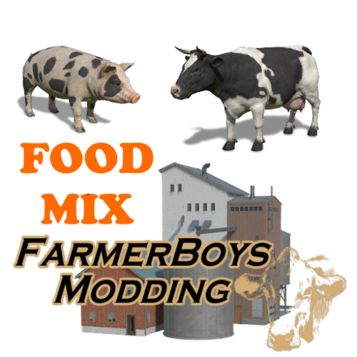
 First off, thank you for the time you spend producing mods for our enjoyment. I loved this mod's design so much I had to make it perfect for my use. I added Lime production and mineral feed production Stone and water = lime straw, silage, and lime = mineral feed Currently tweaking production levels to find a nice balance. This is a great mod for anyone that needs production of farm supplies in a compact footprint. Thanks for inspiring me to further tinker with mods.
 -
 StanceyFIN changed their profile photo
 -
 I’ll check but I don’t think the in game unit does this either. Sometimes we’re limited to giants coding.
 -
 Cannot translate
 -
missing emty haverster can fold it widt the x
-
great havester but missing the emty haverster so it can be foldet widt x bottem
-
Ahoj som tu novy ale chcel by som sa spýtať či by to nešlo do výroby Kravám pridať ešte tu Minerálnu primes ďakujem za odpoveď neviem môžem písať aj po Slovensky alebo použiť Google prekladač. Hallo, ich bin neu hier, aber ich würde gerne fragen, ob es möglich wäre, Mineral Primes zur Produktion der Kühe hinzuzufügen. Vielen Dank für die Antwort. Ich weiß nicht, ob ich auf Slowakisch schreiben oder Google verwenden kann Übersetzer.
-
 Pali68 changed their profile photo
 -
I sent it. I downloaded for USGS Earth Explorer.
-
@c.christensen98 Pm me the coordinates of your Geo. tiff (ie. n51_w003_1arc) and the site you downloaded it from and I will see what is going on with this continuing 'whiteout'.