


Dickieboy
-
Posts
29 -
Joined
-
Last visited
Content Type
Profiles
Gallery
Downloads
Events
Forums
Articles
Everything posted by Dickieboy
-
Appears to still have issues?
-
Because I rarely used the script in 22, and it was easy enough to reverse the spline on the odd occasions I did. Apologies. I have a lot of hedges to place so will try downloading latest now.
-
Not in my experience. If I run a spline in GE and use the new 25 panel placement script, I get the same issue, objects are not rotated correctly if the spline runs North-South, but if I reverse the spline and rerun the placement, it works correctly. (placing hedges)
-
The rotation issue if the spline heads South vs if it heads North has been around for a while. It's something to do with euler rotations I think, but I never got round to figuring it out and fixing it.
-
Terrain Height, Paint Terrain and Spline Placement scripts (Tutorials)
Dickieboy replied to WrinkleysRule's topic in Mapping
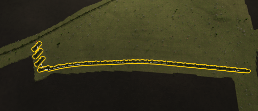
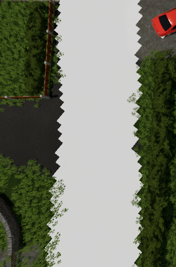
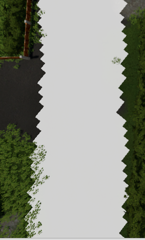
I've just started a new map, and am doing things I haven't done in a long while. I'm using the scripted object placement and as you can see, my hedge is beautifully aligned on the right of the image, but as it starts going towards the top left it no longer aligns the hedge correctly and it gets even further out as it turns the final corner. I seem to recall having this before, but can't remember what I did to fix it. Any ideas? (Hedge is correctly aligned and had freeze transforms on all parts of it)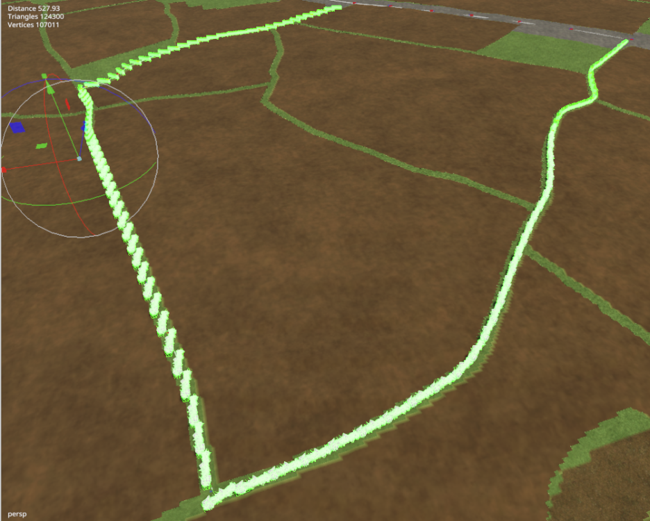
-
I am absolutely definitely NOT looking at another map before I've even released the one I have spent 3 years working on honest. BUT... 😉 I have downloaded a few Lidar files from DEFRA and put them into Google. Where they meet there's a very obvious join/gap. I'm assuming that I need to get the files merged in some way, and have tried to bring them into MicroDem but it gives me a message about missing GDAL and then tells me it can't. the files I have are 1m tif's. Is there a way to do this or not do you know Wrinkley?
-
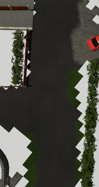
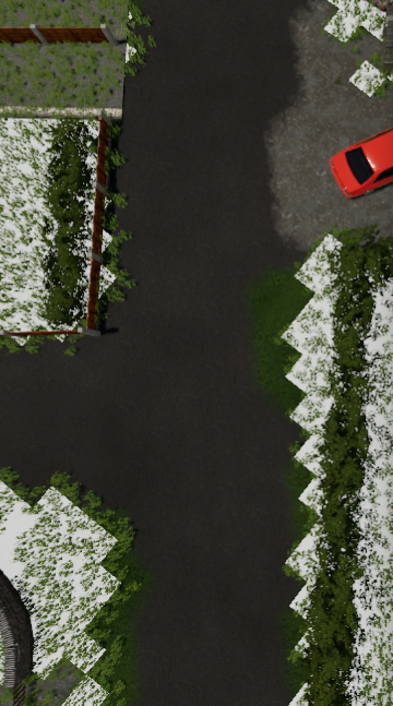
I've been mucking around redoing some of the foliage on my map, and using this script. I'm noticing an odd thing, that the foliage I'm getting is "shifted" or offset to where I'm actually painting by what appears to be a single pixel. This is the masked area, I run the script and it puts grass here You can see on the left that it appears to be outside the masked area, but on the right edge it seems to have respected it better. Now If I then run a different "creator" to remove the foliage from the areas covered by the indoor mask, you'll see it's shifted even more. Before After You can see that none of the grass on the bottom left has been removed (where I'd have expected it to be, but the top right edge has been removed outside of the masked area. Any ideas?
-
Yep. I think I've resolved the snowmesh issue (ie, it shows up in game now - not sure exactly what I did to resolve it but I think maybe I hadn't UV unwrapped it), but Giants have just rejected the mod yet again. Getting pretty pissed off with it now, none of the things they're whinging about as far as I can see are actually part of their published rules, nor do they actually bother giving any documentation or explanation how to resolve these things - snow dust and building shader for example. I can see why so many people don't bother going through the modhub.
-
Anyone any tips on how to make the snowmesh on a roof actually work? I have watched and followed Red Phoenix's video countless times, done what appears to be what he's showing (not helped that he's using different blender set up and addons and whizzes through it), and no matter what I do, the snow mesh just doesn't appear in game. If I use EDC to add snow, other buildings on the map clearly get their snowy roofs, just not mine. What could I be doing wrong? Is there something needed in the xml to get this to work?
-
I think what he means is that a plane is visible at lower levels if the object the plane is supposed to be in, changes shape. For example an icecream cone shape, the plane is big at the top and would stick out either side at the bottom.
-
that's what I initially thought, but it picks up the terrain Density and scale and pixels per unit correctly. What turned out to be the problem seemed connected with the setting for water height. I reset it to 0, and it worked flawlessly. Bit odd really.
-
I really don't want to have to do the indoor mask by hand as I find the painting tools in GE tedious to say the least. I have written a script which will take a start, width and height parameter from transform groups in the same way as you'd define them for a single placeable, and paint the area for you. Just set the TG's in the corners of buildings you want to be excluded from the snow fall. This works create for buildings/objects that are square, but won't work for roads or different shaped buildings particularly easily. However, I see there's a script shipped with the GE which creates a mask for you, using raycasts to find the objects and so on. However, if I run it on my 4x map, the first time it produces a really blocky and unrefined/coarse result. The second time I run it, it just whirrs and whirrs. Has anyone used this script, and if so, used it successfully on a 4x size map?
-
I have 64GB of RAM and an I9, and a long road can take a LOOOOOONG time to do the height adjustment, upwards of 10-20 mins in some cases on my 4x map. So give it chance.
-
@WrinkleysRule Am I right in thinking you just need a script to import the csv to create verts and edges from it? If so, I think I've written one.
-
Probably a bit of a longshot given the absolute lack of resources on this out there, but is anyone able to help with scripting a functioning GUI? I've got the basics of my code done to read the data from the xml, and implement what the player might choose, BUT the gui bit to allow the player to pick their starting farm is just annoying AF.
-
This is brilliant, and will be used extensively on my map, thanks WR. Your updated scripts have been an absolute godsend to me, I prefered doing the painting by hand in 19 with the terrain resolution increasing in 22 I'm getting a much better and more realistic result with the scripts than I was before, and it's sped up the workflow massively. i've been able to redo areas I wasn't happy with in fractions of the time it's taken to get to where I was when I converted to 22.
-
Terrain Height, Paint Terrain and Spline Placement scripts (Tutorials)
Dickieboy replied to WrinkleysRule's topic in Mapping
Also, not sure if the random placement distance works in the spline placement script. My objects are suspiciously all the same distance apart. Regardless of what I set. -
Terrain Height, Paint Terrain and Spline Placement scripts (Tutorials)
Dickieboy replied to WrinkleysRule's topic in Mapping
they're not 90 no. The object is the same one that I used for other splines which worked perfectly. I think I worked out that it's something to do with the direction of the spline in relation to the way the objects should go. Put the S and E at the opposite ends and it works fine. In the meantime, I've just manually rotated the gazillion that were planted wrong on the more complex splines I'd already done 🙂 haha. it's still saving me a considerable amount of time anyway. -
Terrain Height, Paint Terrain and Spline Placement scripts (Tutorials)
Dickieboy replied to WrinkleysRule's topic in Mapping
Bit of a weird one again, used the spline placement to place several splines worth of power lines with zero issue. Doing a freshly placed spline again, the powerlines are all pointing off to one side. Spline is not rotated, and neither is the template object...? -
Terrain Height, Paint Terrain and Spline Placement scripts (Tutorials)
Dickieboy replied to WrinkleysRule's topic in Mapping
Just started playing about with the new paint by spline script. I'm trying to create the random puddle effect you did, but all I get is a band of my colour across the width every 5m (my distance is set to 5 meters. How did you get the more random effect you show? -
Thanks. It turned out that the height scale on the template map was set very different to the value that my 19 map was set. Once done, that sorted it out.
-
I've finally started looking at converting my not quite finished 19 map into 22. I've found a decent 4km template which had all the different ground textures, and I've brought across my weight files and they all show OK. My DEM however feels like it's been "flattened", as in, I've brought through an initial export of objects from the 19 map, and they are floating way above the ground. It's like the vertical units have been set wrong somewhere? The DEM has definitely been brought in, as I can see some features I recognise, they're just not as pronounced as they used to be. Anyone able to help?
